Geolocate

Daet topographic map

Click on the map to display elevation.

About this map

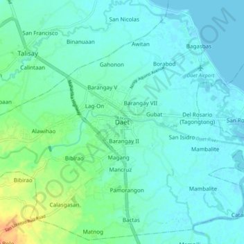
Name: Daet topographic map, elevation, terrain.

Location: Daet, Camarines Norte, Bicol Region, 4600, Philippines (14.07233 122.91570 14.15233 122.99570)

Average elevation: 30 ft

Minimum elevation: -3 ft

Maximum elevation: 135 ft

Other topographic maps

Click on a map to view its topography, its elevation and its terrain.

Bagasbas Beach

Philippines > Camarines Norte > Daet > Bagasbas

Average elevation: 3 ft

Gear up for your next adventure:

🥘Titanium Cookware - Durable, featherlight pots and pans for backpacking
🚗GPS Dash Cams - Record your scenic drives through mountain passes and canyons
📡Handheld GPS Device - Reliable handheld GPS for outdoor navigation
🥾Men's Hiking Boots - Durable, waterproof footwear for rugged terrain and steep inclines
🪶Multi‑Purpose Knife - Useful blade for camp and trail

As an Amazon Associate, this site earns from qualifying purchases at no extra cost to you.