
Make a donation
Gear up for your next adventure:
As an Amazon Associate, this site earns from qualifying purchases at no extra cost to you.
Ballymoney topographic map
Click on the map to display elevation.
Make a donation
Gear up for your next adventure:
As an Amazon Associate, this site earns from qualifying purchases at no extra cost to you.
Ballymoney
In 1837, Lewis's Topographical Dictionary of Ireland, describes Ballymoney as "a market-town and post-town" containing 2,222 inhabitants (11,579 in the broader civil parish) with a long established linen market chiefly supplying the London market, and with "a very extensive trade ... in grain, butter, pork, and general provisions". Transport was largely via the Bann. By 1860, the town was connected to both Belfast and Derry by rail.
Make a donation
Gear up for your next adventure:
As an Amazon Associate, this site earns from qualifying purchases at no extra cost to you.
About this map
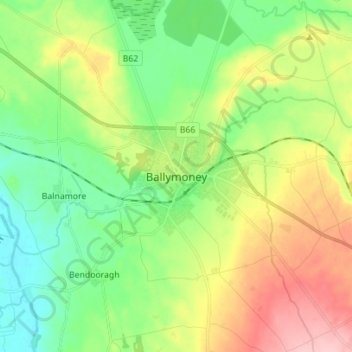
Name: Ballymoney topographic map, elevation, terrain.
Average elevation: 167 ft
Minimum elevation: 0 ft
Maximum elevation: 449 ft
Make a donation
Gear up for your next adventure:
As an Amazon Associate, this site earns from qualifying purchases at no extra cost to you.
Other topographic maps
Click on a map to view its topography, its elevation and its terrain.
Rathlin Island
United Kingdom > Northern Ireland > County Antrim > Church Bay
Average elevation: 33 ft
Make a donation
Gear up for your next adventure:
As an Amazon Associate, this site earns from qualifying purchases at no extra cost to you.
Loughgiel Millennium Centre
United Kingdom > Northern Ireland > County Antrim > Loughguile
Average elevation: 509 ft
Make a donation
Gear up for your next adventure:
As an Amazon Associate, this site earns from qualifying purchases at no extra cost to you.
Shane's Castle Park
United Kingdom > Northern Ireland > County Antrim > Randalstown
Average elevation: 98 ft
Lagan Navigation (Abandoned)
United Kingdom > Northern Ireland > County Antrim > Belfast
Average elevation: 95 ft
Mid and East Antrim District
United Kingdom > Northern Ireland > County Antrim
Average elevation: 364 ft
Make a donation
Gear up for your next adventure:
As an Amazon Associate, this site earns from qualifying purchases at no extra cost to you.
Antrim and Newtownabbey District
United Kingdom > Northern Ireland > County Antrim
Average elevation: 318 ft
Make a donation
Gear up for your next adventure:
As an Amazon Associate, this site earns from qualifying purchases at no extra cost to you.
Causeway Coast AONB
United Kingdom > Northern Ireland > County Antrim > Ballintoy
Average elevation: 112 ft
Kinbane Castle
United Kingdom > Northern Ireland > County Antrim > Ballycastle
Average elevation: 121 ft
Rathlin Island
United Kingdom > Northern Ireland > County Antrim > Church Bay
Average elevation: 33 ft
Make a donation
Gear up for your next adventure:
As an Amazon Associate, this site earns from qualifying purchases at no extra cost to you.
Make a donation
Gear up for your next adventure:
As an Amazon Associate, this site earns from qualifying purchases at no extra cost to you.
Antrim and Newtownabbey District
United Kingdom > Northern Ireland > County Antrim
Average elevation: 318 ft
Make a donation
Gear up for your next adventure:
As an Amazon Associate, this site earns from qualifying purchases at no extra cost to you.
Make a donation
Gear up for your next adventure:
As an Amazon Associate, this site earns from qualifying purchases at no extra cost to you.
Mid and East Antrim District
United Kingdom > Northern Ireland > County Antrim
Average elevation: 364 ft
Make a donation
Gear up for your next adventure:
As an Amazon Associate, this site earns from qualifying purchases at no extra cost to you.
Antrim and Newtownabbey District
United Kingdom > Northern Ireland > County Antrim
Average elevation: 318 ft