Geolocate

Mandya topographic map

Click on the map to display elevation.

Mandya

Mandya is located at 12°31′N 76°54′E / 12.52°N 76.9°E / 12.52; 76.9. It has an average elevation of 678 metres (2,224 ft).

Wikipedia (CC-BY-SA 3.0)

About this map

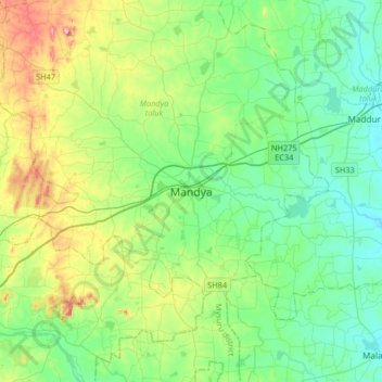
Name: Mandya topographic map, elevation, terrain.

Location: Mandya, Mandya taluk, Mandya, Karnataka, 571401, India (12.36389 76.73620 12.68389 77.05620)

Average elevation: 2,274 ft

Minimum elevation: 2,018 ft

Maximum elevation: 3,005 ft

Gear up for your next adventure:

🔦Powerful Headlamps - Ultra-bright hands-free lighting for night navigation
🛰️Handheld GPS Units - Professional satellite navigators for precise backcountry mapping
🥤Water Filter Bottle - All‑in‑one filter bottle for safe hydration
🔌Solar Panel Charger - Charge gear sustainably outdoors
🪶Thermal Camp Blanket - Extra warmth for cold nights

As an Amazon Associate, this site earns from qualifying purchases at no extra cost to you.