Geolocate

Rivne topographic map

Click on the map to display elevation.

About this map

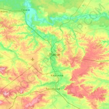
Name: Rivne topographic map, elevation, terrain.

Location: Rivne, Rivne Oblast, 33000-33499, Ukraine (50.45962 26.09132 50.77962 26.41132)

Average elevation: 702 ft

Minimum elevation: 535 ft

Maximum elevation: 968 ft

Gear up for your next adventure:

📡Handheld GPS Device - Reliable handheld GPS for outdoor navigation
🏔️Mountain Trail Maps - High‑detail maps for popular peaks
🎒Day Hiking Backpack - Lightweight backpack perfect for day trips and outdoor adventures
🌡️Handheld Weather Meters - Measure wind, temp, and pressure for safe mountain travel
🦶Carbon Trekking Poles - Reduce knee impact on steep descents with ultra-light poles

As an Amazon Associate, this site earns from qualifying purchases at no extra cost to you.