
Make a donation
Gear up for your next adventure:
As an Amazon Associate, this site earns from qualifying purchases at no extra cost to you.
Geluwe topographic map
Click on the map to display elevation.
Make a donation
Gear up for your next adventure:
As an Amazon Associate, this site earns from qualifying purchases at no extra cost to you.
Geluwe
Geluwe ligt in Zandlemig Vlaanderen op een hoogte van 20 meter. De hoogte loopt op tot 44 meter in het gehucht Terhand.
Make a donation
Gear up for your next adventure:
As an Amazon Associate, this site earns from qualifying purchases at no extra cost to you.
About this map
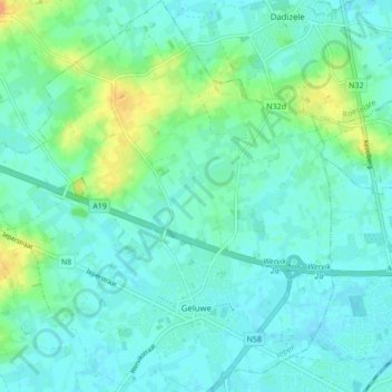
Name: Geluwe topographic map, elevation, terrain.
Location: Geluwe, Wervik, Ieper, West-Vlaanderen, Vlaanderen, 8940, België (50.79978 3.02545 50.85403 3.10685)
Average elevation: 79 ft
Minimum elevation: 52 ft
Maximum elevation: 164 ft
Make a donation
Gear up for your next adventure:
As an Amazon Associate, this site earns from qualifying purchases at no extra cost to you.
Other topographic maps
Click on a map to view its topography, its elevation and its terrain.
Kruiseke
België > West-Vlaanderen > Ieper > Wervik
Op 11 november 1914 vielen de Duitsers opnieuw Ieper aan via de Meenseweg (komende van Menen) ter hoogte van Kruiseke. Ze waren met hun 18.000 manschappen duidelijk in de meerderheid, maar konden de 8.000 Britten die hun de toegang ontzegden niet verslaan. De volgende dag viel de eerste sneeuw wat voor een…
Average elevation: 92 ft