
Brooks Range topographic map
Click on the map to display elevation.
About this map
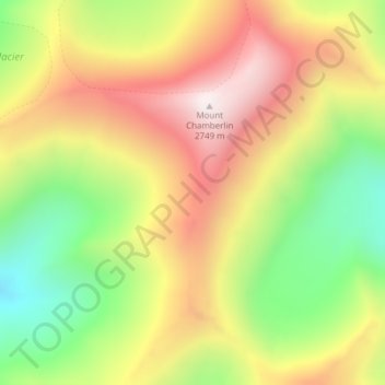
Name: Brooks Range topographic map, elevation, terrain.
Location: Brooks Range, North Slope Borough, Alaska, United States (69.27135 -144.91375 69.27145 -144.91365)
Average elevation: 6,939 ft
Minimum elevation: 5,177 ft
Maximum elevation: 8,924 ft
North Slope Borough trails, hiking, mountain biking, running and outdoor activities
Other topographic maps
Click on a map to view its topography, its elevation and its terrain.
Utqiaġvik
United States > Alaska > North Slope Borough
Despite the extreme northern location, temperatures at Utqiagvik are moderated by the surrounding topography. The Arctic Ocean is on three sides, and flat tundra stretches some 200 mi (320 km) to the south. No wind barriers or protected valleys exist where dense cold air can settle or form temperature…
Average elevation: 13 ft
Toolik Lake
United States > Alaska > North Slope Borough
Tussock tundra dominates the terrain surrounding the lake. Other plant communities in the area include wet sedge tundra, as well drier heath tundra found at higher elevations. Low growing shrubs are abundant, including birches and willows. Trees are not present. Since surveys began, there has been a 19 percent…
Average elevation: 2,398 ft
Utqiaġvik
United States > Alaska > North Slope Borough
Despite the extreme northern location, temperatures at Utqiagvik are moderated by the surrounding topography. The Arctic Ocean is on three sides, and flat tundra stretches some 200 mi (320 km) to the south. No wind barriers or protected valleys exist where dense cold air can settle or form temperature…
Average elevation: 13 ft