
Hutchinson topographic map
Interactive map
Click on the map to display elevation.
About this map
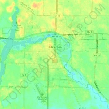
Name: Hutchinson topographic map, elevation, terrain.
Location: Hutchinson, McLeod County, Minnesota, 55350, United States (44.85246 -94.42203 44.91404 -94.32808)
Average elevation: 1,063 ft
Minimum elevation: 1,020 ft
Maximum elevation: 1,115 ft
Other topographic maps
Click on a map to view its topography, its elevation and its terrain.
Glencoe
United States > Minnesota > McLeod County
Glencoe, McLeod County, Minnesota, United States
Average elevation: 1,014 ft
Lester Prairie
United States > Minnesota > McLeod County
Lester Prairie, McLeod County, Minnesota, United States
Average elevation: 984 ft
Sherman
United States > Minnesota > McLeod County > Sherman
Sherman, Winsted Township, McLeod County, Minnesota, United States
Average elevation: 1,040 ft
Silver Lake
United States > Minnesota > McLeod County
Silver Lake, McLeod County, Minnesota, United States
Average elevation: 1,050 ft
Winsted
United States > Minnesota > McLeod County > Winsted > Winsted
Winsted, McLeod County, Minnesota, 55395, United States
Average elevation: 1,017 ft