Geolocate

Erding topographic map

Click on the map to display elevation.

About this map

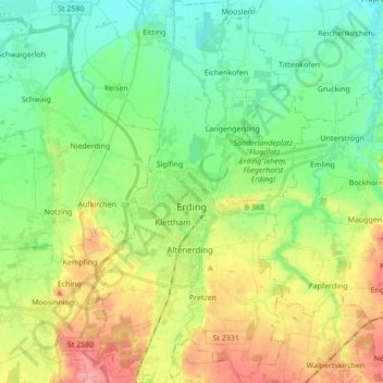
Name: Erding topographic map, elevation, terrain.

Location: Erding, Landkreis Erding, Bavaria, 85435, Germany (48.25331 11.86084 48.36812 11.96101)

Average elevation: 1,526 ft

Minimum elevation: 1,424 ft

Maximum elevation: 1,703 ft

Gear up for your next adventure:

🪶Wildlife Field Guides - Learn animal tracking and species ID
🪶Thermal Camp Blanket - Extra warmth for cold nights
📻Weather Alert Radios - Stay informed of storm risks while off-the-grid
🏫Relief Map Kits - Hands-on tools for teaching landforms and elevation
🔭Stargazing Telescopes - Perfect for camping in low-light pollution areas shown on maps

As an Amazon Associate, this site earns from qualifying purchases at no extra cost to you.