Geolocate

Sefro topographic map

Click on the map to display elevation.

About this map

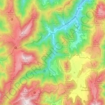
Name: Sefro topographic map, elevation, terrain.

Location: Sefro, Macerata, Marche, 62025, Italy (43.09683 12.90350 43.17069 12.99577)

Average elevation: 3,048 ft

Minimum elevation: 1,516 ft

Maximum elevation: 4,573 ft

Gear up for your next adventure:

🔥Camping Stove - Portable stove for camping and backcountry cooking
📶Satellite Messenger - Communication device off‑grid
🥄Camping Utensil Set - Lightweight utensils for outdoor meals
🧤Tactile Hiking Gloves - Keep hands warm while operating GPS and smartphone screens
🧢Outdoor Hiking Hat - Sun protection hat for outdoor explorers

As an Amazon Associate, this site earns from qualifying purchases at no extra cost to you.