
Thank you for supporting this site ❤️
Make a donation
Make a donation
Gear up for your next adventure:
As an Amazon Associate, this site earns from qualifying purchases at no extra cost to you.
Alcaucín topographic map
Click on the map to display elevation.
Thank you for supporting this site ❤️
Make a donation
Make a donation
Gear up for your next adventure:
As an Amazon Associate, this site earns from qualifying purchases at no extra cost to you.
About this map
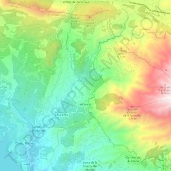
Name: Alcaucín topographic map, elevation, terrain.
Location: Alcaucín, La Axarquía, Malaga, Andalusia, 29711, Spain (36.87238 -4.16330 36.95271 -4.04906)
Average elevation: 2,474 ft
Minimum elevation: 531 ft
Maximum elevation: 6,339 ft
Thank you for supporting this site ❤️
Make a donation
Make a donation
Gear up for your next adventure:
As an Amazon Associate, this site earns from qualifying purchases at no extra cost to you.