
Make a donation
Gear up for your next adventure:
As an Amazon Associate, this site earns from qualifying purchases at no extra cost to you.
Sonneberg topographic map
Click on the map to display elevation.
Make a donation
Gear up for your next adventure:
As an Amazon Associate, this site earns from qualifying purchases at no extra cost to you.
Sonneberg
"The Sonneberg Castle was also called Sonneberg Castle or the Haus zu Sonneberg in old documents. In 480 Süne or Süno, Duke of Franconia, built this castle because of the Thuringian incursions ..." so it says on page 64 in the topography of the Duke of Saxe-Meiningen's share in the Duchy of Coburg from the year 1781. This not uncritical representation is based on the history of the Franks by Abbot Johannes Trithemius from 1514.
Make a donation
Gear up for your next adventure:
As an Amazon Associate, this site earns from qualifying purchases at no extra cost to you.
About this map
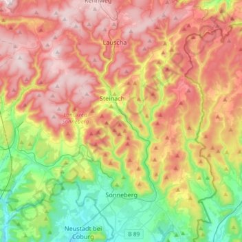
Name: Sonneberg topographic map, elevation, terrain.
Location: Sonneberg, Landkreis Sonneberg, Thuringia, 96515, Germany (50.32086 11.11405 50.50751 11.28479)
Average elevation: 1,923 ft
Minimum elevation: 1,073 ft
Maximum elevation: 2,841 ft
Make a donation
Gear up for your next adventure:
As an Amazon Associate, this site earns from qualifying purchases at no extra cost to you.