
Make a donation
Gear up for your next adventure:
As an Amazon Associate, this site earns from qualifying purchases at no extra cost to you.
Onze-Lieve-Vrouw topographic map
Click on the map to display elevation.
Make a donation
Gear up for your next adventure:
As an Amazon Associate, this site earns from qualifying purchases at no extra cost to you.
About this map
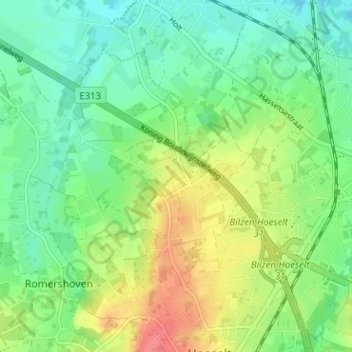
Name: Onze-Lieve-Vrouw topographic map, elevation, terrain.
Location: Onze-Lieve-Vrouw, Hoeselt, Tongeren, Limburg, 3730, België (50.85036 5.46049 50.89036 5.50049)
Average elevation: 200 ft
Minimum elevation: 121 ft
Maximum elevation: 331 ft
Make a donation
Gear up for your next adventure:
As an Amazon Associate, this site earns from qualifying purchases at no extra cost to you.
Other topographic maps
Click on a map to view its topography, its elevation and its terrain.
Sint-Huibrechts-Hern
België > Limburg > Tongeren > Hoeselt
Sint-Huibrechts-Hern is gelegen in vochtig-Haspengouw. Ten oosten van de kom ligt een bosachtig gebied. De hoogte varieert van 70 tot 112 meter. Zie verder onder Vrijhern.
Average elevation: 299 ft