
Magsaysay topographic map
Click on the map to display elevation.
Magsaysay
Magsaysay, one of the eleven municipalities in the Occidental Mindoro, lies on the southernmost part of Mindoro Island, and is adjacent to the municipality of San Jose on the north; on the east separated by chain of valleys and mountains in the municipality of Bulalacao, Oriental Mindoro; on the south, by Garza Island; and on the west by Iling Island. It is facing the China Sea, with vast plains and valleys. It is characterized by rugged terrain with plain areas. Slope ranges from level to very steep sloping areas. The highest point of elevation is 543 feet above sea level.
About this map
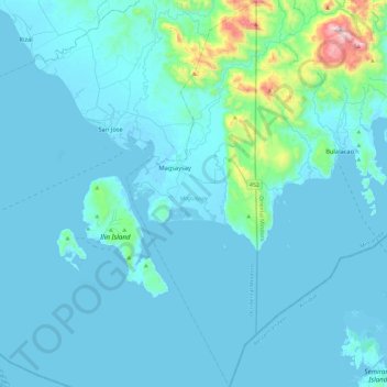
Name: Magsaysay topographic map, elevation, terrain.
Location: Magsaysay, Occidental Mindoro, Mimaropa, Philippines (12.04741 121.08536 12.50453 121.24394)
Average elevation: 203 ft
Minimum elevation: -7 ft
Maximum elevation: 2,900 ft
Other topographic maps
Click on a map to view its topography, its elevation and its terrain.
Cabra Island
Philippines > Occidental Mindoro > Lubang
With a length of about 4.5 km (2.8 miles) and about 2.9 km (1.8 miles) at its widest, the island has a flat terrain with the highest elevation at 60.96 metres (around 200 feet). A particular rock islet near one beach is considered by locals as a symbol of the island given its shape as a cabra (Spanish for…
Average elevation: 56 ft