
Iserlohn topographic map
Click on the map to display elevation.
About this map
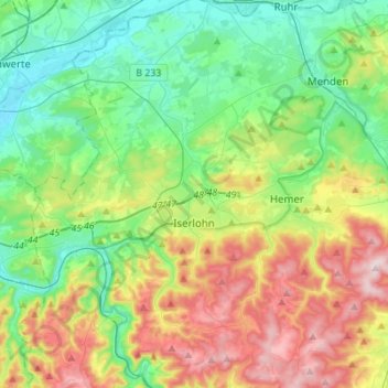
Name: Iserlohn topographic map, elevation, terrain.
Location: Iserlohn, Märkischer Kreis, North Rhine-Westphalia, Germany (51.30176 7.58412 51.47365 7.74499)
Average elevation: 823 ft
Minimum elevation: 338 ft
Maximum elevation: 1,788 ft
Other topographic maps
Click on a map to view its topography, its elevation and its terrain.
Ebbegebirge
Germany > North Rhine-Westphalia > Märkischer Kreis > Herscheid
The highest elevation in the Ebbe Mountains is the Nordhelle (663.3 m above NN) between Valbert and Herscheid. Other notable hills are the: Rehberg (645.9 m), Rüenhardt (636.0 m), Waldberg (ca. 635 m), Rothenstein (ca. 600 m), Der Griesing (552,6 m), Homert (538,3 m) and Kahler Kopf (540.1 m).
Average elevation: 1,804 ft