
Thank you for supporting this site ❤️
Make a donation
Make a donation
Gear up for your next adventure:
As an Amazon Associate, this site earns from qualifying purchases at no extra cost to you.
Barot topographic map
Click on the map to display elevation.
Thank you for supporting this site ❤️
Make a donation
Make a donation
Gear up for your next adventure:
As an Amazon Associate, this site earns from qualifying purchases at no extra cost to you.
About this map
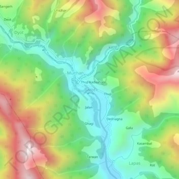
Name: Barot topographic map, elevation, terrain.
Location: Barot, Padhar, Mandi, Himachal Pradesh, 175013, India (32.01773 76.82521 32.05773 76.86521)
Average elevation: 7,057 ft
Minimum elevation: 5,807 ft
Maximum elevation: 8,911 ft
Thank you for supporting this site ❤️
Make a donation
Make a donation
Gear up for your next adventure:
As an Amazon Associate, this site earns from qualifying purchases at no extra cost to you.