
Thank you for supporting this site ❤️
Make a donation
Make a donation
Gear up for your next adventure:
As an Amazon Associate, this site earns from qualifying purchases at no extra cost to you.
Tepe topographic map
Click on the map to display elevation.
Thank you for supporting this site ❤️
Make a donation
Make a donation
Gear up for your next adventure:
As an Amazon Associate, this site earns from qualifying purchases at no extra cost to you.
About this map
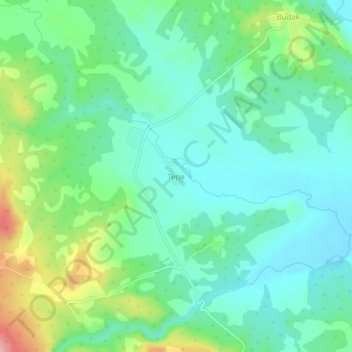
Name: Tepe topographic map, elevation, terrain.
Location: Tepe, Lice, Diyarbakır, Southeastern Anatolia Region, Turkey (38.36667 40.71751 38.40667 40.75751)
Average elevation: 2,684 ft
Minimum elevation: 2,539 ft
Maximum elevation: 3,058 ft
Thank you for supporting this site ❤️
Make a donation
Make a donation
Gear up for your next adventure:
As an Amazon Associate, this site earns from qualifying purchases at no extra cost to you.