
Make a donation
Gear up for your next adventure:
As an Amazon Associate, this site earns from qualifying purchases at no extra cost to you.
Morris topographic map
Click on the map to display elevation.
Make a donation
Gear up for your next adventure:
As an Amazon Associate, this site earns from qualifying purchases at no extra cost to you.
About this map
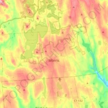
Name: Morris topographic map, elevation, terrain.
Average elevation: 932 ft
Minimum elevation: 535 ft
Maximum elevation: 1,296 ft
Northwest Hills Planning Region trails, hiking, mountain biking, running and outdoor activities
Make a donation
Gear up for your next adventure:
As an Amazon Associate, this site earns from qualifying purchases at no extra cost to you.
Other topographic maps
Click on a map to view its topography, its elevation and its terrain.
Winchester Center
United States > Connecticut > Northwest Hills Planning Region > Winchester
Average elevation: 1,263 ft
The Matterhorn
United States > Connecticut > Northwest Hills Planning Region > Canaan
Average elevation: 1,516 ft
East Hartland
United States > Connecticut > Northwest Hills Planning Region > Hartland
Average elevation: 1,102 ft
Burrville
United States > Connecticut > Northwest Hills Planning Region > Torrington
Average elevation: 958 ft
Make a donation
Gear up for your next adventure:
As an Amazon Associate, this site earns from qualifying purchases at no extra cost to you.
South Kent
United States > Connecticut > Northwest Hills Planning Region > Kent
Average elevation: 620 ft
Thomaston Rod & Gun Club
United States > Connecticut > Northwest Hills Planning Region > Litchfield
Average elevation: 915 ft
Sharon Avenue Park
United States > Connecticut > Northwest Hills Planning Region > Torrington
Average elevation: 751 ft
Browns Corner
United States > Connecticut > Northwest Hills Planning Region > New Hartford
Average elevation: 696 ft
Make a donation
Gear up for your next adventure:
As an Amazon Associate, this site earns from qualifying purchases at no extra cost to you.
Tyler Lake Heights
United States > Connecticut > Northwest Hills Planning Region > Goshen
Average elevation: 1,325 ft
West Goshen
United States > Connecticut > Northwest Hills Planning Region > Goshen
Average elevation: 1,270 ft