
Thank you for supporting this site ❤️
Make a donation
Make a donation
Gear up for your next adventure:
As an Amazon Associate, this site earns from qualifying purchases at no extra cost to you.
Geremeas topographic map
Click on the map to display elevation.
Thank you for supporting this site ❤️
Make a donation
Make a donation
Gear up for your next adventure:
As an Amazon Associate, this site earns from qualifying purchases at no extra cost to you.
About this map
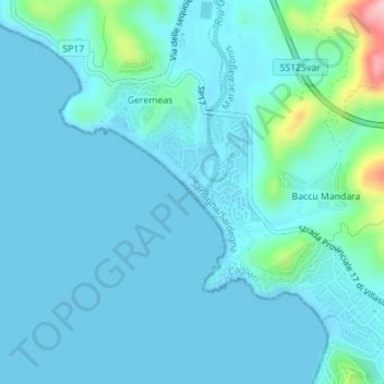
Name: Geremeas topographic map, elevation, terrain.
Location: Geremeas, Maracalagonis, Cagliari, Sardegna, 09040, Italia (39.15996 9.37465 39.16939 9.38597)
Average elevation: 75 ft
Minimum elevation: -13 ft
Maximum elevation: 640 ft
Thank you for supporting this site ❤️
Make a donation
Make a donation
Gear up for your next adventure:
As an Amazon Associate, this site earns from qualifying purchases at no extra cost to you.
Other topographic maps
Click on a map to view its topography, its elevation and its terrain.
Villaggio dei Gigli
Italia > Sardegna > Cagliari > Maracalagonis > Villaggio dei Gigli
Average elevation: 669 ft