
Make a donation
Gear up for your next adventure:
As an Amazon Associate, this site earns from qualifying purchases at no extra cost to you.
Coinco topographic map
Click on the map to display elevation.
Make a donation
Gear up for your next adventure:
As an Amazon Associate, this site earns from qualifying purchases at no extra cost to you.
About this map
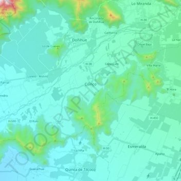
Name: Coinco topographic map, elevation, terrain.
Average elevation: 1,224 ft
Minimum elevation: 732 ft
Maximum elevation: 4,993 ft
Make a donation
Gear up for your next adventure:
As an Amazon Associate, this site earns from qualifying purchases at no extra cost to you.
Other topographic maps
Click on a map to view its topography, its elevation and its terrain.
El Molino Viejo
Chile > O'Higgins Region > Provincia de Cachapoal > Requínoa > Pichiguao
Average elevation: 1,224 ft
Condominio San José
Chile > O'Higgins Region > Provincia de Cachapoal > Requínoa
Average elevation: 1,378 ft
Make a donation
Gear up for your next adventure:
As an Amazon Associate, this site earns from qualifying purchases at no extra cost to you.
Rinconada de Doñihue Sur
Chile > O'Higgins Region > Provincia de Cachapoal > Doñihue > Rinconada de Doñihue Sur
Average elevation: 1,312 ft