Geolocate

North Commons topographic map

Click on the map to display elevation.

About this map

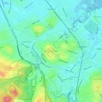
Name: North Commons topographic map, elevation, terrain.

Location: North Commons, Quincy, Norfolk County, Massachusetts, 02269, United States (42.22916 -71.04030 42.26916 -71.00030)

Average elevation: 85 ft

Minimum elevation: -3 ft

Maximum elevation: 331 ft

Norfolk County trails, hiking, mountain biking, running and outdoor activities

Other topographic maps

Click on a map to view its topography, its elevation and its terrain.

Gear up for your next adventure:

🔋Solar Power Banks - Keep your GPS and phone charged in remote wilderness areas
🔥Fast-Boil Camping Stoves - Efficient cooking systems for quick trail meals
🧴Hand Sanitizer - Keep hands clean while hiking
🪶LED Camping Lantern - Bright lantern for camp lighting
🗺️Topographic Maps - Detailed topo maps for hiking, exploring and outdoor navigation

As an Amazon Associate, this site earns from qualifying purchases at no extra cost to you.