
Thank you for supporting this site ❤️
Make a donation
Make a donation
Gear up for your next adventure:
As an Amazon Associate, this site earns from qualifying purchases at no extra cost to you.
Srirangam topographic map
Click on the map to display elevation.
Thank you for supporting this site ❤️
Make a donation
Make a donation
Gear up for your next adventure:
As an Amazon Associate, this site earns from qualifying purchases at no extra cost to you.
About this map
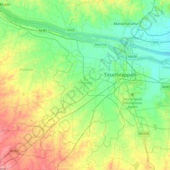
Name: Srirangam topographic map, elevation, terrain.
Location: Srirangam, Tiruchirappalli District, Tamil Nadu, India (10.64357 78.46307 10.92147 78.82463)
Average elevation: 308 ft
Minimum elevation: 194 ft
Maximum elevation: 541 ft
Thank you for supporting this site ❤️
Make a donation
Make a donation
Gear up for your next adventure:
As an Amazon Associate, this site earns from qualifying purchases at no extra cost to you.