
Make a donation
Gear up for your next adventure:
As an Amazon Associate, this site earns from qualifying purchases at no extra cost to you.
Drie Fonteinen topographic map
Click on the map to display elevation.
Make a donation
Gear up for your next adventure:
As an Amazon Associate, this site earns from qualifying purchases at no extra cost to you.
Drie Fonteinen
Ter hoogte van de vroegere sluis van Drie Fonteinen werd rond 1975 een deel van het parkdomein verkaveld tot de wijk Lenterik, genoemd naar Sint-Lenterik en de gelijknamige kapel in het Domein Drie Fonteinen.
Make a donation
Gear up for your next adventure:
As an Amazon Associate, this site earns from qualifying purchases at no extra cost to you.
About this map
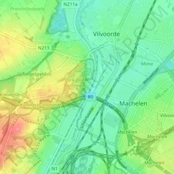
Name: Drie Fonteinen topographic map, elevation, terrain.
Average elevation: 85 ft
Minimum elevation: -7 ft
Maximum elevation: 246 ft
Make a donation
Gear up for your next adventure:
As an Amazon Associate, this site earns from qualifying purchases at no extra cost to you.
Other topographic maps
Click on a map to view its topography, its elevation and its terrain.
Vilvoorde
België > Vlaams-Brabant > Halle-Vilvoorde > Vilvoorde
Het hoogtepunt van zijn bloei beleefde Vilvoorde in de 14de eeuw. De stad was een belangrijk centrum dat met Leuven en Brussel wedijverde om de belangrijkste stad van Brabant te worden. Uit deze periode dateren verschillende grote bouwwerken. In 1357 werd de stad helemaal omwald. Deze vesten hadden…
Average elevation: 79 ft