Geolocate

Wharncliffe Side topographic map

Click on the map to display elevation.

Wharncliffe Side

Wharcliffe Side is located on the west bank of the River Don, approximately six miles (9.7 km) northwest of Sheffield city centre, and one mile (1.6 km) northwest of Oughtibridge, south of the confluence of the Ewden beck and the River Don. The village is at an elevation of 435 feet (133 m) and the A6102 road passes through the village.

Wikipedia (CC-BY-SA 3.0)

About this map

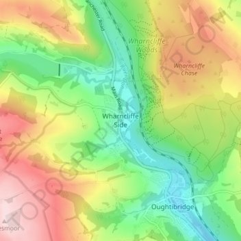
Name: Wharncliffe Side topographic map, elevation, terrain.

Location: Wharncliffe Side, Sheffield, South Yorkshire, England, S35 0EZ, United Kingdom (53.42902 -1.57231 53.46902 -1.53231)

Average elevation: 719 ft

Minimum elevation: 276 ft

Maximum elevation: 1,299 ft

Other topographic maps

Click on a map to view its topography, its elevation and its terrain.

Parkwood Springs

United Kingdom > England > Sheffield

Average elevation: 308 ft

River Loxley

United Kingdom > England > Sheffield > Dungworth

Average elevation: 541 ft

Crookes and Crosspool

United Kingdom > England > Sheffield

Average elevation: 597 ft

Concord Park

United Kingdom > England > Sheffield

Average elevation: 299 ft

Norfolk Heritage Park

United Kingdom > England > Sheffield

Average elevation: 410 ft

Ecclesfield

United Kingdom > England > Sheffield > Whitley

Ecclesfield lies in the north of Sheffield, about 4 miles (7 km) north of the city centre. The suburb of Ecclesfield is in the south-east of the civil parish with the suburbs Chapeltown and High Green to the north, and Grenoside to the west. Its altitude is 60 metres (200 ft) to 120 metres (390 ft) above mean…

Average elevation: 420 ft

Ponderosa

United Kingdom > England > Sheffield

Average elevation: 371 ft

Grenoside

United Kingdom > England > Sheffield > Whitley

Average elevation: 397 ft

Bushey Wood

United Kingdom > England > Sheffield

Average elevation: 581 ft

River Rivelin

United Kingdom > England > Sheffield

Average elevation: 663 ft

Bradfield

United Kingdom > England > Sheffield

Average elevation: 938 ft

Bingham Park

United Kingdom > England > Sheffield

Average elevation: 620 ft

Woodthorpe Park

United Kingdom > England > Sheffield

Average elevation: 440 ft

River Sheaf

United Kingdom > England > Sheffield

Average elevation: 522 ft

Meersbrook Park

United Kingdom > England > Sheffield

Average elevation: 404 ft

Ecclesfield

United Kingdom > England > Sheffield > Whitley

Ecclesfield lies in the north of Sheffield, about 4 miles (7 km) north of the city centre. The suburb of Ecclesfield is in the south-east of the civil parish with the suburbs Chapeltown and High Green to the north, and Grenoside to the west. Its altitude is 60 metres (200 ft) to 120 metres (390 ft) above mean…

Average elevation: 420 ft

Crookes Valley Park

United Kingdom > England > Sheffield

Average elevation: 410 ft

Walkley

United Kingdom > England > Sheffield

Average elevation: 387 ft

Endcliffe Wood

United Kingdom > England > Sheffield

Average elevation: 522 ft

Ecclesfield

United Kingdom > England > Sheffield > Whitley

Average elevation: 712 ft

Millhouses Park

United Kingdom > England > Sheffield

Average elevation: 472 ft

Don Valley Bowl

United Kingdom > England > Sheffield

Average elevation: 177 ft

River Sheaf

United Kingdom > England > Sheffield

Average elevation: 554 ft

Endcliffe Park

United Kingdom > England > Sheffield

Average elevation: 528 ft

Stocksbridge

United Kingdom > England > Sheffield > Deepcar

Average elevation: 771 ft

Graves Park

United Kingdom > England > Sheffield

Average elevation: 571 ft

Hesley Wood

United Kingdom > England > Sheffield > Chapeltown

Average elevation: 361 ft

Devonshire Green

United Kingdom > England > Sheffield

Average elevation: 295 ft

Kelham Island

United Kingdom > England > Sheffield

Average elevation: 259 ft

Gear up for your next adventure:

🦟Ultrasonic Repellers - Create a bug-free zone at your camp or rest stop
🔋Solar Power Banks - Keep your GPS and phone charged in remote wilderness areas
GPS Sports Watch - GPS watch for running, hiking and training
🧭Hiking Compass - Precision compass for reliable navigation in the wilderness
🔭Compact Binoculars - HD vision for scouting terrain and identifying distant landmarks

As an Amazon Associate, this site earns from qualifying purchases at no extra cost to you.