
Thank you for supporting this site ❤️
Make a donation
Make a donation
Gear up for your next adventure:
As an Amazon Associate, this site earns from qualifying purchases at no extra cost to you.
Bethania topographic map
Click on the map to display elevation.
Thank you for supporting this site ❤️
Make a donation
Make a donation
Gear up for your next adventure:
As an Amazon Associate, this site earns from qualifying purchases at no extra cost to you.
About this map
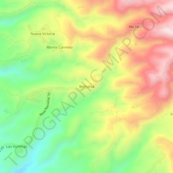
Name: Bethania topographic map, elevation, terrain.
Location: Bethania, Yepocapa, Chimaltenango, Guatemala (14.45840 -91.02374 14.49840 -90.98374)
Average elevation: 3,596 ft
Minimum elevation: 2,812 ft
Maximum elevation: 4,455 ft
Thank you for supporting this site ❤️
Make a donation
Make a donation
Gear up for your next adventure:
As an Amazon Associate, this site earns from qualifying purchases at no extra cost to you.