
Cairo topographic map
Click on the map to display elevation.
About this map
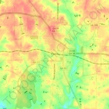
Name: Cairo topographic map, elevation, terrain.
Location: Cairo, Grady County, Georgia, 39828, United States (30.84130 -84.24206 30.91238 -84.16482)
Average elevation: 249 ft
Minimum elevation: 135 ft
Maximum elevation: 328 ft
Grady County trails, hiking, mountain biking, running and outdoor activities
Other topographic maps
Click on a map to view its topography, its elevation and its terrain.