Geolocate

Ashgrove topographic map

Click on the map to display elevation.

About this map

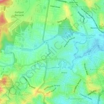
Name: Ashgrove topographic map, elevation, terrain.

Location: Ashgrove, Brisbane City, Queensland, 4060, Australia (-27.45506 152.96238 -27.43093 153.00648)

Average elevation: 184 ft

Minimum elevation: 26 ft

Maximum elevation: 906 ft

Other topographic maps

Click on a map to view its topography, its elevation and its terrain.

Teneriffe

Australia > Queensland > Brisbane City

Average elevation: 36 ft

Constitution Hill

Australia > Queensland > Brisbane City

Average elevation: 472 ft

Gear up for your next adventure:

🥾Men's Hiking Boots - Durable, waterproof footwear for rugged terrain and steep inclines
🎒Trekking Poles - Sturdy poles for balance and stability on rough terrain
Backpacking Tents - Weight-optimized shelters for multi-day topographic surveys
🪶Fire Starter Kit - Reliable fire starter for survival and camping
❄️Traction Cleats - Prevent slips on icy trails during winter hikes

As an Amazon Associate, this site earns from qualifying purchases at no extra cost to you.