
Make a donation
Gear up for your next adventure:
As an Amazon Associate, this site earns from qualifying purchases at no extra cost to you.
Öhringen topographic map
Click on the map to display elevation.
Make a donation
Gear up for your next adventure:
As an Amazon Associate, this site earns from qualifying purchases at no extra cost to you.
Öhringen
Öhringen liegt im westlichen, tiefer gelegenen Teil der Hohenloher Ebene, zwischen der Keuperstufe der Schwäbisch-Fränkischen Waldberge und dem Kochertal. Die Stadt breitet sich über das flache Tal der Ohrn aus, eines kleinen Flusses, der etwa 10 km talwärts im Stadtteil Ohrnberg in den Kocher mündet. Das Stadtgebiet liegt zwischen 168 m ü. NN im Kochertal an der Kreisgrenze bei Möglingen und 486 m ü. NN im Mainhardter Wald auf der Karlsfurter Ebene, die noch zum Stadtteil Michelbach gehört. Die Höhe in der Kernstadt selbst schwankt zwischen 215 m ü. NN und 280 m ü. NN.
Make a donation
Gear up for your next adventure:
As an Amazon Associate, this site earns from qualifying purchases at no extra cost to you.
About this map
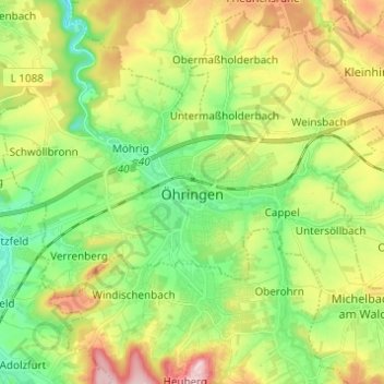
Name: Öhringen topographic map, elevation, terrain.
Average elevation: 883 ft
Minimum elevation: 620 ft
Maximum elevation: 1,289 ft
Make a donation
Gear up for your next adventure:
As an Amazon Associate, this site earns from qualifying purchases at no extra cost to you.