
Make a donation
Gear up for your next adventure:
As an Amazon Associate, this site earns from qualifying purchases at no extra cost to you.
Calais topographic map
Click on the map to display elevation.
Make a donation
Gear up for your next adventure:
As an Amazon Associate, this site earns from qualifying purchases at no extra cost to you.
About this map
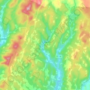
Name: Calais topographic map, elevation, terrain.
Location: Calais, Washington County, Vermont, United States (44.30449 -72.55078 44.42583 -72.37990)
Average elevation: 1,191 ft
Minimum elevation: 689 ft
Maximum elevation: 2,116 ft
Make a donation
Gear up for your next adventure:
As an Amazon Associate, this site earns from qualifying purchases at no extra cost to you.
Other topographic maps
Click on a map to view its topography, its elevation and its terrain.
Northfield Center
United States > Vermont > Washington County > Northfield
Average elevation: 1,119 ft
Make a donation
Gear up for your next adventure:
As an Amazon Associate, this site earns from qualifying purchases at no extra cost to you.
Northfield Center
United States > Vermont > Washington County > Northfield
Average elevation: 1,119 ft
South Cabot
United States > Vermont > Washington County > Cabot > South Cabot
Average elevation: 1,575 ft
Make a donation
Gear up for your next adventure:
As an Amazon Associate, this site earns from qualifying purchases at no extra cost to you.