
Thank you for supporting this site ❤️
Make a donation
Make a donation
Gear up for your next adventure:
As an Amazon Associate, this site earns from qualifying purchases at no extra cost to you.
Förstgen topographic map
Click on the map to display elevation.
Thank you for supporting this site ❤️
Make a donation
Make a donation
Gear up for your next adventure:
As an Amazon Associate, this site earns from qualifying purchases at no extra cost to you.
About this map
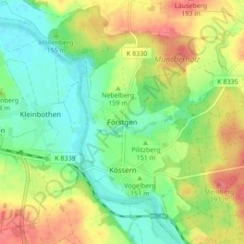
Name: Förstgen topographic map, elevation, terrain.
Location: Förstgen, Grimma, Landkreis Leipzig, Sachsen, Deutschland (51.16913 12.76574 51.20913 12.80574)
Average elevation: 509 ft
Minimum elevation: 420 ft
Maximum elevation: 627 ft
Thank you for supporting this site ❤️
Make a donation
Make a donation
Gear up for your next adventure:
As an Amazon Associate, this site earns from qualifying purchases at no extra cost to you.