
Make a donation
Gear up for your next adventure:
As an Amazon Associate, this site earns from qualifying purchases at no extra cost to you.
Boegoeberg Dam topographic map
Click on the map to display elevation.
Make a donation
Gear up for your next adventure:
As an Amazon Associate, this site earns from qualifying purchases at no extra cost to you.
About this map
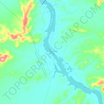
Name: Boegoeberg Dam topographic map, elevation, terrain.
Average elevation: 3,068 ft
Minimum elevation: 2,874 ft
Maximum elevation: 3,904 ft
Make a donation
Gear up for your next adventure:
As an Amazon Associate, this site earns from qualifying purchases at no extra cost to you.
Other topographic maps
Click on a map to view its topography, its elevation and its terrain.
Douglas
South Africa > Northern Cape > Pixley ka Seme District Municipality > Siyancuma Local Municipality
Douglas has a record of its elevation above sea level of 1030.22 meters (3379.99 feet). Comparing Douglas district's yearly temperature to South Africa's averages, the records show that it is 4.01% higher with a temperature 25.23 °C (77.41 °F). Douglas is known for its Subtropical desert climate with 38.78…
Average elevation: 3,314 ft