Geolocate

Bryan topographic map

Click on the map to display elevation.

About this map

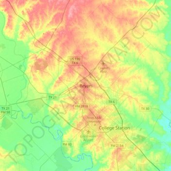
Name: Bryan topographic map, elevation, terrain.

Location: Bryan, Brazos County, Texas, 77803, United States (30.51436 -96.52996 30.83436 -96.20996)

Average elevation: 292 ft

Minimum elevation: 180 ft

Maximum elevation: 436 ft

Brazos County trails, hiking, mountain biking, running and outdoor activities

Gear up for your next adventure:

Backpacking Tent - Lightweight and durable tent for multi‑day hikes
🪶LED Camping Lantern - Bright lantern for camp lighting
🧭Map Reading Tools - Tools and kits for map navigation
🧢Sun Protection Hats - Wide-brimmed and UPF-rated hats for high-altitude sun safety
🦟Ultrasonic Repellers - Create a bug-free zone at your camp or rest stop

As an Amazon Associate, this site earns from qualifying purchases at no extra cost to you.