
Thank you for supporting this site ❤️
Make a donation
Make a donation
Gear up for your next adventure:
As an Amazon Associate, this site earns from qualifying purchases at no extra cost to you.
Concordia topographic map
Click on the map to display elevation.
Thank you for supporting this site ❤️
Make a donation
Make a donation
Gear up for your next adventure:
As an Amazon Associate, this site earns from qualifying purchases at no extra cost to you.
About this map
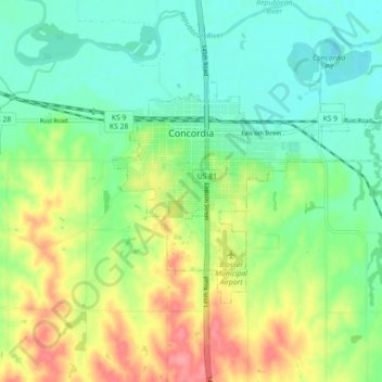
Name: Concordia topographic map, elevation, terrain.
Location: Concordia, Cloud County, Kansas, 66901, United States (39.54084 -97.68262 39.58132 -97.59335)
Average elevation: 1,417 ft
Minimum elevation: 1,319 ft
Maximum elevation: 1,594 ft
Cloud County trails, hiking, mountain biking, running and outdoor activities
Thank you for supporting this site ❤️
Make a donation
Make a donation
Gear up for your next adventure:
As an Amazon Associate, this site earns from qualifying purchases at no extra cost to you.