
Make a donation
Gear up for your next adventure:
As an Amazon Associate, this site earns from qualifying purchases at no extra cost to you.
Seine-Port topographic map
Click on the map to display elevation.
Make a donation
Gear up for your next adventure:
As an Amazon Associate, this site earns from qualifying purchases at no extra cost to you.
Seine-Port
La commune est classée en zone de sismicité 1, correspondant à une sismicité très faible. L'altitude varie de 37 mètres à 85 mètres pour le point le plus haut, le centre de la ville se situant à environ 49 mètres d'altitude (mairie).
Make a donation
Gear up for your next adventure:
As an Amazon Associate, this site earns from qualifying purchases at no extra cost to you.
About this map
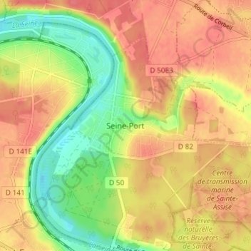
Name: Seine-Port topographic map, elevation, terrain.
Average elevation: 220 ft
Minimum elevation: 108 ft
Maximum elevation: 295 ft
Make a donation
Gear up for your next adventure:
As an Amazon Associate, this site earns from qualifying purchases at no extra cost to you.