
Hortichuela topographic map
Interactive map
Click on the map to display elevation.
About this map
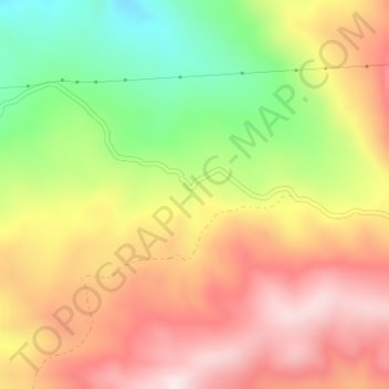
Name: Hortichuela topographic map, elevation, terrain.
Location: Hortichuela, Alcalá la Real, Jaén, Andalucía, 23688, España (37.42435 -4.00148 37.44435 -3.98148)
Average elevation: 3,297 ft
Minimum elevation: 2,523 ft
Maximum elevation: 3,940 ft
Other topographic maps
Click on a map to view its topography, its elevation and its terrain.
Villalobos
España > Andalucía > Alcalá la Real
Villalobos, Alcalá la Real, Jaén, Andalucía, 23688, España
Average elevation: 3,005 ft
Charilla
España > Andalucía > Alcalá la Real
Charilla, Alcalá la Real, Jaén, Andalucía, 23692, España
Average elevation: 3,022 ft
La Pedriza
España > Andalucía > Alcalá la Real
La Pedriza, Alcalá la Real, Jaén, Andalucía, 23688, España
Average elevation: 3,169 ft
La Rábita
España > Andalucía > Alcalá la Real
La Rábita, Alcalá la Real, Jaén, Andalucía, España
Average elevation: 2,156 ft