Geolocate

Spavinaw topographic map

Click on the map to display elevation.

About this map

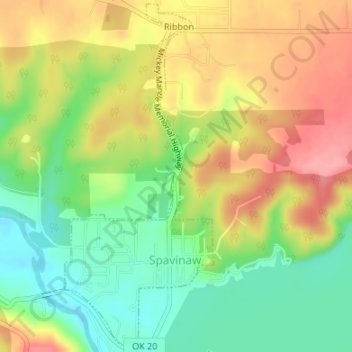
Name: Spavinaw topographic map, elevation, terrain.

Location: Spavinaw, Mayes County, Oklahoma, 74366, United States (36.38444 -95.05716 36.41083 -95.04293)

Average elevation: 787 ft

Minimum elevation: 620 ft

Maximum elevation: 971 ft

Mayes County trails, hiking, mountain biking, running and outdoor activities

Other topographic maps

Click on a map to view its topography, its elevation and its terrain.

Pryor Creek

United States > Oklahoma > Mayes County

Average elevation: 623 ft

Rose

United States > Oklahoma > Mayes County

Average elevation: 984 ft

Hoot Owl

United States > Oklahoma > Mayes County

Average elevation: 709 ft

Snake Creek

United States > Oklahoma > Mayes County

Average elevation: 925 ft

Langley

United States > Oklahoma > Mayes County > Langley

Average elevation: 725 ft

Salina

United States > Oklahoma > Mayes County > Salina

Average elevation: 709 ft

Gear up for your next adventure:

🪑Ultralight Camp Chairs - Portable seating for resting after a long day of mapping
🪶Survival Guide Book - Expert advice for emergency preparedness
🍳Camping Cook Set - Complete cookware for outdoor meals
🏥Hiking First Aid Kits - Comprehensive medical kits for remote trail injuries
🌧️Backpack Rain Cover - Keep gear dry in wet weather

As an Amazon Associate, this site earns from qualifying purchases at no extra cost to you.