Geolocate

Carle Place topographic map

Click on the map to display elevation.

About this map

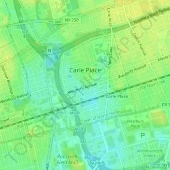
Name: Carle Place topographic map, elevation, terrain.

Location: Carle Place, Town of North Hempstead, Nassau County, New York, 11514, United States (40.74208 -73.62430 40.75823 -73.59989)

Average elevation: 112 ft

Minimum elevation: 79 ft

Maximum elevation: 135 ft

Other topographic maps

Click on a map to view its topography, its elevation and its terrain.

Westbury South

United States > New York > Nassau County > Salisbury

Average elevation: 118 ft

Roslyn

United States > New York > Nassau County > Roslyn

Average elevation: 164 ft

Gear up for your next adventure:

🧷Carabiner Set - Durable clips for gear attachment
📖Nature Tracking Books - Learn to track wildlife and terrain
📷Action Camera - Capture your outdoor adventures in HD
🪶Trail Camera - Capture wildlife on your hikes
🚗GPS Dash Cams - Record your scenic drives through mountain passes and canyons

As an Amazon Associate, this site earns from qualifying purchases at no extra cost to you.