
Make a donation
Gear up for your next adventure:
As an Amazon Associate, this site earns from qualifying purchases at no extra cost to you.
Haaltert topographic map
Click on the map to display elevation.
Make a donation
Gear up for your next adventure:
As an Amazon Associate, this site earns from qualifying purchases at no extra cost to you.
About this map
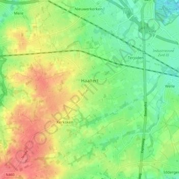
Name: Haaltert topographic map, elevation, terrain.
Location: Haaltert, Aalst, Oost-Vlaanderen, 9450, België (50.88263 3.95411 50.91635 4.04148)
Average elevation: 118 ft
Minimum elevation: 16 ft
Maximum elevation: 246 ft
Make a donation
Gear up for your next adventure:
As an Amazon Associate, this site earns from qualifying purchases at no extra cost to you.
Other topographic maps
Click on a map to view its topography, its elevation and its terrain.
Erpe-Mere
België > Oost-Vlaanderen > Aalst > Mere
Erpe-Mere ligt op uitlopers van de heuvelzone van de Vlaamse Ardennen en in de Denderstreek. Het gebied ten noorden van de weg Aalst-Gent (N9) ligt op 10 tot 30 meter hoogte, het gebied tussen de N9 en de E40 Brussel-Gent ligt op een hoogte tussen 25 en 50 meter en het gebied ten zuiden daarvan heeft…
Average elevation: 125 ft
Make a donation
Gear up for your next adventure:
As an Amazon Associate, this site earns from qualifying purchases at no extra cost to you.