Geolocate

Oseiro topographic map

Click on the map to display elevation.

About this map

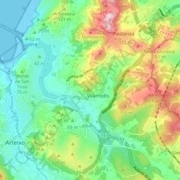
Name: Oseiro topographic map, elevation, terrain.

Location: Oseiro, Arteixo, La Coruña, Galicia, 15141, España (43.29618 -8.51818 43.34591 -8.45267)

Average elevation: 262 ft

Minimum elevation: -46 ft

Maximum elevation: 801 ft

Other topographic maps

Click on a map to view its topography, its elevation and its terrain.

O Monte Pequeno

España > Galicia > La Coruña > Arteixo

Average elevation: 197 ft

A Estación

España > Galicia > La Coruña > Arteixo

Average elevation: 482 ft

A Cachopa

España > Galicia > La Coruña > Arteixo

Average elevation: 217 ft

Corteo de Arriba

España > Galicia > La Coruña > Arteixo

Average elevation: 554 ft

Gomesende

España > Galicia > La Coruña > Arteixo

Average elevation: 469 ft

O Igrexario

España > Galicia > La Coruña > Arteixo

Average elevation: 463 ft

Sabón

España > Galicia > La Coruña > Arteixo

Average elevation: 138 ft

Ponte

España > Galicia > La Coruña > Arteixo

Average elevation: 256 ft

O Monte do Lobo

España > Galicia > La Coruña > Arteixo > O Puntido

Average elevation: 98 ft

A Estación

España > Galicia > La Coruña > Arteixo

Average elevation: 482 ft

Gear up for your next adventure:

🧭GPS Watch Accessories - Bands and chargers for GPS watches
💧Water Purification System - Clean water on the trail with reliable purifiers
🏕️Family Camping Gear - Essentials for group camping trips
📦Gear Storage Bags - Organize and protect outdoor equipment
🔋Solar Power Banks - Keep your GPS and phone charged in remote wilderness areas

As an Amazon Associate, this site earns from qualifying purchases at no extra cost to you.