
Castelnaud topographic map
Interactive map
Click on the map to display elevation.
About this map
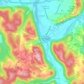
Name: Castelnaud topographic map, elevation, terrain.
Average elevation: 472 ft
Minimum elevation: 190 ft
Maximum elevation: 807 ft
Other topographic maps
Click on a map to view its topography, its elevation and its terrain.
Le Soucaillou
France > Nouvelle-Aquitaine > Dordogne > Castelnaud-la-Chapelle > Le Soucaillou
Le Soucaillou, Castelnaud-la-Chapelle, Sarlat-la-Canéda, Dordogne, Nouvelle-Aquitaine, France métropolitaine, 24250, France
Average elevation: 440 ft
Tournepicque
France > Nouvelle-Aquitaine > Dordogne > Castelnaud-la-Chapelle
Tournepicque, Castelnaud-la-Chapelle, Sarlat-la-Canéda, Dordogne, Nouvelle-Aquitaine, France métropolitaine, 24250, France
Average elevation: 469 ft