
Make a donation
Gear up for your next adventure:
As an Amazon Associate, this site earns from qualifying purchases at no extra cost to you.
Hog Lake topographic map
Click on the map to display elevation.
Make a donation
Gear up for your next adventure:
As an Amazon Associate, this site earns from qualifying purchases at no extra cost to you.
About this map
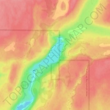
Name: Hog Lake topographic map, elevation, terrain.
Location: Hog Lake, Spokane County, Washington, United States (47.37376 -117.80965 47.38140 -117.79833)
Average elevation: 2,178 ft
Minimum elevation: 1,985 ft
Maximum elevation: 2,260 ft
Spokane County trails, hiking, mountain biking, running and outdoor activities
Make a donation
Gear up for your next adventure:
As an Amazon Associate, this site earns from qualifying purchases at no extra cost to you.
Other topographic maps
Click on a map to view its topography, its elevation and its terrain.
Make a donation
Gear up for your next adventure:
As an Amazon Associate, this site earns from qualifying purchases at no extra cost to you.
Medical Lake
United States > Washington > Spokane County > Medical Lake > Medical Lake
Average elevation: 2,451 ft
Make a donation
Gear up for your next adventure:
As an Amazon Associate, this site earns from qualifying purchases at no extra cost to you.