
Thank you for supporting this site ❤️
Make a donation
Make a donation
Gear up for your next adventure:
As an Amazon Associate, this site earns from qualifying purchases at no extra cost to you.
Polmont topographic map
Click on the map to display elevation.
Thank you for supporting this site ❤️
Make a donation
Make a donation
Gear up for your next adventure:
As an Amazon Associate, this site earns from qualifying purchases at no extra cost to you.
About this map
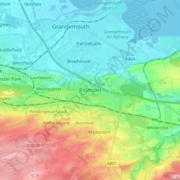
Name: Polmont topographic map, elevation, terrain.
Location: Polmont, Falkirk, Scotland, FK2 0PX, United Kingdom (55.95059 -3.74746 56.03059 -3.66746)
Average elevation: 213 ft
Minimum elevation: -7 ft
Maximum elevation: 728 ft
Thank you for supporting this site ❤️
Make a donation
Make a donation
Gear up for your next adventure:
As an Amazon Associate, this site earns from qualifying purchases at no extra cost to you.