
Thank you for supporting this site ❤️
Make a donation
Make a donation
Gear up for your next adventure:
As an Amazon Associate, this site earns from qualifying purchases at no extra cost to you.
Setouchi topographic map
Click on the map to display elevation.
Thank you for supporting this site ❤️
Make a donation
Make a donation
Gear up for your next adventure:
As an Amazon Associate, this site earns from qualifying purchases at no extra cost to you.
About this map
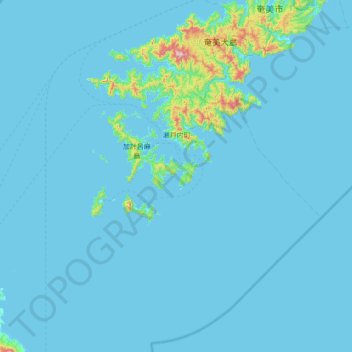
Name: Setouchi topographic map, elevation, terrain.
Location: Setouchi, Oshima County, Kagoshima Prefecture, Japan (27.79745 128.90423 28.37507 129.59460)
Average elevation: 85 ft
Minimum elevation: 0 ft
Maximum elevation: 2,208 ft
Thank you for supporting this site ❤️
Make a donation
Make a donation
Gear up for your next adventure:
As an Amazon Associate, this site earns from qualifying purchases at no extra cost to you.