
Town of Nanticoke topographic map
Interactive map
Click on the map to display elevation.
About this map
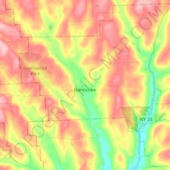
Name: Town of Nanticoke topographic map, elevation, terrain.
Average elevation: 1,299 ft
Minimum elevation: 945 ft
Maximum elevation: 1,604 ft
Other topographic maps
Click on a map to view its topography, its elevation and its terrain.
Town of Binghamton
United States > New York > Broome County
Town of Binghamton, Broome County, New York, 13903, United States
Average elevation: 1,368 ft
Crocker Island
United States > New York > Broome County > Village of Johnson City
Crocker Island, Village of Johnson City, Town of Union, Broome County, New York, 13902, United States
Average elevation: 1,348 ft
Nineveh
United States > New York > Broome County
Nineveh, Town of Colesville, Broome County, New York, United States
Average elevation: 1,109 ft
City of Binghamton
United States > New York > Broome County
City of Binghamton, Broome County, New York, 13905, United States
Average elevation: 1,053 ft
Oquaga Lake
United States > New York > Broome County > Town of Sanford
Oquaga Lake, Town of Sanford, Broome County, New York, United States
Average elevation: 1,690 ft
Binghamton
United States > New York > Broome County > Binghamton
Binghamton, Broome County, New York, 13903, United States
Average elevation: 1,302 ft
Town of Vestal
United States > New York > Broome County
Town of Vestal, Union, Broome County, New York, United States
Average elevation: 1,220 ft
Village of Johnson City
United States > New York > Broome County
Village of Johnson City, Town of Union, Broome County, New York, 13790, United States
Average elevation: 1,014 ft
Flowers
United States > New York > Broome County > Flowers
Flowers, Windsor Town, Broome County, New York, 13865, United States
Average elevation: 1,588 ft
Village of Deposit
United States > New York > Broome County
Village of Deposit, Town of Sanford, Broome County, New York, United States
Average elevation: 1,168 ft