Geolocate

Nineveh topographic map

Click on the map to display elevation.

About this map

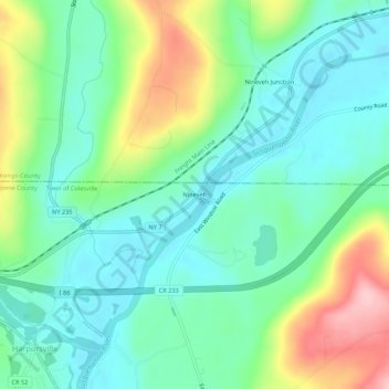
Name: Nineveh topographic map, elevation, terrain.

Location: Nineveh, Town of Colesville, Broome County, New York, United States (42.17425 -75.62241 42.21425 -75.58241)

Average elevation: 1,109 ft

Minimum elevation: 925 ft

Maximum elevation: 1,535 ft

Broome County trails, hiking, mountain biking, running and outdoor activities

Other topographic maps

Click on a map to view its topography, its elevation and its terrain.

Town of Lisle

United States > New York > Broome County

Average elevation: 1,247 ft

Town of Kirkwood

United States > New York > Broome County

Average elevation: 1,316 ft

Town of Windsor

United States > New York > Broome County

Average elevation: 1,424 ft

Town of Triangle

United States > New York > Broome County

Average elevation: 1,342 ft

Town of Colesville

United States > New York > Broome County

Average elevation: 1,388 ft

Town of Sanford

United States > New York > Broome County

Average elevation: 1,516 ft

Town of Fenton

United States > New York > Broome County

Average elevation: 1,033 ft

Town of Binghamton

United States > New York > Broome County

Average elevation: 1,371 ft

Town of Conklin

United States > New York > Broome County

Average elevation: 1,250 ft

Gear up for your next adventure:

Backpacking Tent - Lightweight and durable tent for multi‑day hikes
🛏️Cold Weather Sleeping Bag - Warm sleeping bag for cold conditions
🪑Ultralight Camp Chairs - Portable seating for resting after a long day of mapping
🎒Gear Packing Cubes - Organize your backpack efficiently
💧Water Filtration Bottles - Safely drink from streams and lakes while exploring

As an Amazon Associate, this site earns from qualifying purchases at no extra cost to you.