
Make a donation
Gear up for your next adventure:
As an Amazon Associate, this site earns from qualifying purchases at no extra cost to you.
Cap Béar topographic map
Click on the map to display elevation.
Make a donation
Gear up for your next adventure:
As an Amazon Associate, this site earns from qualifying purchases at no extra cost to you.
About this map
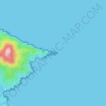
Name: Cap Béar topographic map, elevation, terrain.
Average elevation: 33 ft
Minimum elevation: 0 ft
Maximum elevation: 640 ft
Make a donation
Gear up for your next adventure:
As an Amazon Associate, this site earns from qualifying purchases at no extra cost to you.
Other topographic maps
Click on a map to view its topography, its elevation and its terrain.
Phare du Cap Béar
France > Occitanie > Pyrénées-Orientales > Port-Vendres
En 1905, la première tour est abandonnée car trop souvent dans la brume. Le deuxième phare est construit d’une hauteur de 27 mètres à une altitude d’environ 50 mètres : son élévation est donc de 80 mètres au-dessus du niveau de la mer ; il est muni d'un feu à trois éclats blancs émis toutes les 20 secondes.
Average elevation: 43 ft