Geolocate

Vermilion topographic map

Click on the map to display elevation.

About this map

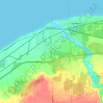
Name: Vermilion topographic map, elevation, terrain.

Location: Vermilion, Erie County, Ohio, United States (41.37968 -82.37871 41.43080 -82.28238)

Average elevation: 630 ft

Minimum elevation: 564 ft

Maximum elevation: 774 ft

Erie County trails, hiking, mountain biking, running and outdoor activities

Other topographic maps

Click on a map to view its topography, its elevation and its terrain.

Sandusky

United States > Ohio > Erie County > Sandusky > Sandusky

Average elevation: 604 ft

Huron Junction

United States > Ohio > Erie County

Average elevation: 600 ft

Chaska Beach

United States > Ohio > Erie County > Huron

Average elevation: 581 ft

North Palm Beach

United States > Ohio > Erie County > Huron

Average elevation: 581 ft

Gear up for your next adventure:

🌧️Backpack Rain Cover - Keep gear dry in wet weather
Solar GPS Watches - Advanced multisport watches with built-in topographic maps
Backpacking Tent - Lightweight and durable tent for multi‑day hikes
🧭Map Reading Tools - Tools and kits for map navigation
🚗GPS Dash Cams - Record your scenic drives through mountain passes and canyons

As an Amazon Associate, this site earns from qualifying purchases at no extra cost to you.