Geolocate

Sungai Raya topographic map

Click on the map to display elevation.

About this map

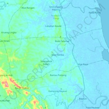
Name: Sungai Raya topographic map, elevation, terrain.

Location: Sungai Raya, Aceh Timur, Aceh, Sumatra, Indonesia (4.63191 97.80599 4.71241 97.97639)

Average elevation: 59 ft

Minimum elevation: -16 ft

Maximum elevation: 633 ft

Other topographic maps

Click on a map to view its topography, its elevation and its terrain.

Aluebutuha

Indonesia > Aceh > Aceh Timur

Average elevation: 43 ft

Tanjung Tualang

Indonesia > Aceh > Aceh Timur

Average elevation: 7 ft

Bukit Raja

Indonesia > Aceh > Aceh Timur

Average elevation: 164 ft

Gear up for your next adventure:

Camping Coffee Makers - Enjoy premium coffee at the summit or campsite
🪓Survival Multi‑Tool - Versatile tool for camp and trail tasks
🔌USB Car Charger - Car charger for on‑the‑go power needs
🌎3D Topographic Globes - Raised relief globes for a tactile understanding of geography
🧣Merino Neck Gaiters - Multi-functional headwear for wind and sun protection

As an Amazon Associate, this site earns from qualifying purchases at no extra cost to you.