
Vilar da Veiga topographic map
Interactive map
Click on the map to display elevation.
About this map
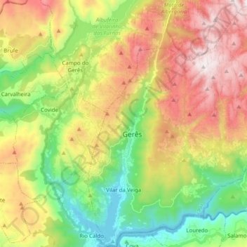
Name: Vilar da Veiga topographic map, elevation, terrain.
Location: Vilar da Veiga, Terras de Bouro, Braga, Portugal (41.67498 -8.19295 41.78929 -8.06057)
Average elevation: 2,300 ft
Minimum elevation: 479 ft
Maximum elevation: 4,672 ft
Other topographic maps
Click on a map to view its topography, its elevation and its terrain.
Campo do Gerês
Portugal > Braga > Terras de Bouro
Campo do Gerês, Terras de Bouro, Braga, 4840-030, Portugal
Average elevation: 2,493 ft