Geolocate

Visavadar topographic map

Click on the map to display elevation.

Visavadar

Visavadar is located at 21°23′N 70°41′E / 21.38°N 70.68°E / 21.38; 70.68. It has an average elevation of 91 metres (298 feet).

Wikipedia (CC-BY-SA 3.0)

About this map

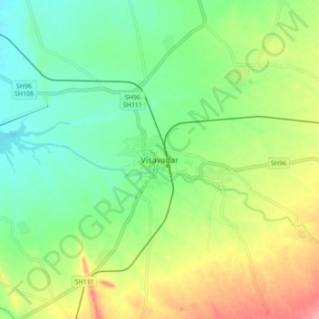
Name: Visavadar topographic map, elevation, terrain.

Location: Visavadar, Visavadar Taluka, Junagadh District, Gujarat, 362130, India (21.30171 70.71343 21.38171 70.79343)

Average elevation: 476 ft

Minimum elevation: 361 ft

Maximum elevation: 666 ft

Gear up for your next adventure:

🛡️Insect Repellent - Protection against bugs during outdoor activities
🥾Women's Hiking Boots - Top-rated trail boots with ankle support and superior grip
🌄Hiking Binoculars - Compact binoculars for scenic views and trail spotting
🗺️Topographic Maps - Detailed topo maps for hiking, exploring and outdoor navigation
🧷Carabiner Set - Durable clips for gear attachment

As an Amazon Associate, this site earns from qualifying purchases at no extra cost to you.