Geolocate
👉 Easily get elevation data in JSON, GeoTIFF and KML formats using Elevation API
Thank you for supporting this site ❤️
Make a donation

Dragoon topographic map

Click on the map to display elevation.

About this map

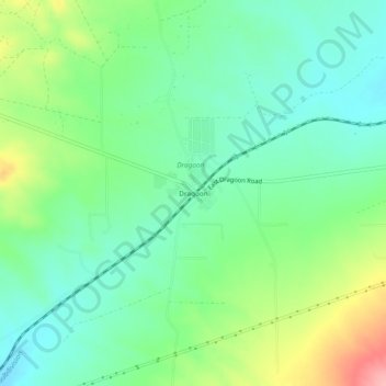
Name: Dragoon topographic map, elevation, terrain.

Location: Dragoon, Cochise County, Arizona, 85609, United States (32.00814 -110.05868 32.04814 -110.01868)

Average elevation: 4,665 ft

Minimum elevation: 4,534 ft

Maximum elevation: 4,951 ft

Cochise County trails, hiking, mountain biking, running and outdoor activities

Other topographic maps

Click on a map to view its topography, its elevation and its terrain.

Whetstone

United States > Arizona > Cochise County

Average elevation: 4,403 ft

Huachuca City

United States > Arizona > Cochise County

Average elevation: 4,360 ft

Whetstone

United States > Arizona > Cochise County

Average elevation: 4,344 ft

Gear up for your next adventure:

🚁Photography Drones - Capture stunning aerial views of landforms and topography
📶Satellite Messenger - Communication device off‑grid
🚗GPS Dash Cams - Record your scenic drives through mountain passes and canyons
🥘Titanium Cookware - Durable, featherlight pots and pans for backpacking
🧦Merino Wool Socks - Moisture-wicking, blister-preventing socks for long treks

As an Amazon Associate, this site earns from qualifying purchases at no extra cost to you.